U.S. WEATHER SATELLITE SENDS FIRST CLOUD PHOTOS TO EARTH
TV Camera Aboard “Tiros” Spots Storm in Early Orbits
WASHINGTON, April 1 — In a dramatic stride for American science, the United States yesterday placed into orbit a compact, picture‑taking weather satellite that transmitted the first cloud‑cover photographs ever returned from space. President Eisenhower, shown the prints only hours after they were taken, hailed the achievement as “a marvelous development.”
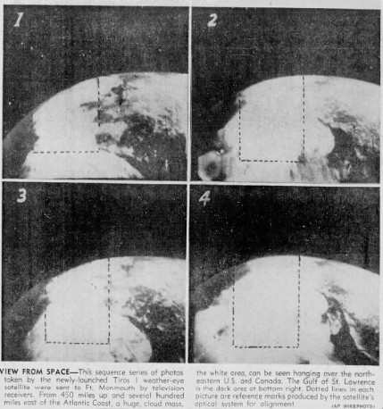
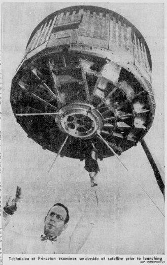
The 270‑pound satellite, known as Tiros, was launched from Cape Canaveral at 6:40 a.m. and quickly settled into what officials described as the most accurate circular orbit yet achieved by an American vehicle. From an altitude of roughly 450 miles, its tiny television cameras captured sweeping views of the Gulf of St. Lawrence and surrounding regions.
Pictures Rushed to White House
The photographs—relayed first to the Army Signal Corps Laboratory at Fort Monmouth, N.J.—were flown to Washington and placed before the President within five hours of their creation. “The earth doesn’t look so big when you see that curvature,” Mr. Eisenhower remarked as he studied the crisp cloud patterns and dark land‑and‑sea outlines.
Federal Space Administrator T. Keith Glennan later presented a montage of four rapidly sequenced images, each covering an area of some 640,000 square miles. The first centered on Seven Islands near the mouth of the St. Lawrence River; subsequent frames traced the cloud deck eastward toward the Atlantic.
Storm Sighted Over Midwest
Even in its earliest circuits, Tiros demonstrated its value by detecting a large storm mass over the American Midwest. Meteorologists said the satellite’s performance confirmed “the feasibility of space weather stations—no question about it,” according to Harry Wexler of the U.S. Weather Bureau.
Officials emphasized that the new satellite is the first in a planned series intended to give forecasters early warning of hurricanes, tornadoes, and other severe disturbances. Some scientists believe such systems may one day contribute to actual weather control.
Peaceful Purposes Stressed
Senator Lyndon B. Johnson, chairman of the Senate Space Committee, called the launch “the best space news that we have had for a long time,” adding that it marked a major step toward peaceful uses of outer space.
Dr. Abe Silverstein of the federal space agency dismissed speculation that Tiros might serve as a military reconnaissance device. Its cameras, he said, are designed solely for meteorological observation and lack the resolution required for spying.
Thor‑Able Rocket Performs Flawlessly
The Air Force Thor‑Able booster, rising through low clouds and leaving a brilliant white vapor trail, placed the satellite into orbit approximately two hours before the space agency confirmed its near‑perfect trajectory. Tiros circles the globe once every 99.15 minutes and is expected to transmit for about three months, though it may remain aloft for “tens of years.”
With its two glass‑sized TV cameras and compact radio transmitters, Tiros represents a modest but decisive beginning to a global weather‑watch system. A more advanced satellite is scheduled for launch later this year.
As America and the Soviet Union continue their contest for leadership in the heavens, yesterday’s success stands as a clear demonstration that the United States is pressing forward—not with weapons, but with instruments aimed at understanding the planet we share.
Courtesy of The Newark Star-Ledger April 2, 1960 via Newspapers.com